
"For the truth is that I already know as much about my fate as I need to know. The day will come when I will die. So the only matter of consequence before me is what I will do with my allotted time. I can remain on shore, paralyzed with fear or I can raise my sails and dip and soar in the breeze." ―Richard Bode
We had another busy day, full of exploring. We drove up the Fundy Coast to Alma, Cape Enrage and the Hopewell Rocks...all great places to see the power of the tide in the Bay of Fundy. Our first stop was in Alma to see the harbor with its lobster boats sitting on the ocean's floor. From there we drove to Cape Engage to take in the view and look at the lighthouse.
Low tide in Alma

 The cute town of Alma
 We've been keeping our eyes open for a moose, but this is the only one we've seen...so far.
 Our second stop for the day was at Cape Enrage, which sits 145' above the bay and has a spectacular view. Cape Enrage derives its name from the large reef that extends south into Chignecto Bay, which causes the water off the point to become extremely violent, particularly at half tide when the reef is partially exposed and the water is moving quickly. There has been a lighthouse here since 1840. The current light has been here for over 140 years. It's one of the oldest lighthouses on New Brunswick’s Fundy coastline.


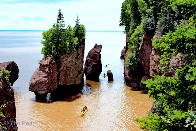
 After taking in the sights at Cape Enrage we headed to Hopewell Rocks, also called the Flowerpots Rocks. They are rock formations caused by tidal erosion. They stand 40–70 feet tall. They are located on the shores of the upper reaches of the Bay of Fundy at Hopewell Cape. Due to the extreme tidal range of the Bay of Fundy, the base of the formations are covered in water twice a day, but it's possible to view the formations from ground level at low tide.
Low tide in Alma


The large volume of water flowing into and out of the Bay of Fundy modifies the landscape surrounding it. After the retreat of the glaciers in the region following the last ice age, surface water filtering through cracks in the cliff has eroded and separated the formations from the rest of the cliff face. Meanwhile, advancing and retreating tides and the associated waves have eroded the base of the rocks at a faster rate than the tops, resulting in their unusual shapes. The rocks are ever changing and eroding...in 2016 parts of one of the formations collapsed.
The Flowerpots at low tide.
 We didn't get a chance to come back at high tide, but this is what the same area looks like at high tide.
 This picture shows you how much water comes and goes in this area...four times a day.
 Some of the rock formations at Hopewell Rocks.

 Stan is standing on the ocean floor...water would be well above the seaweed above his head at high tide.


 This whole area will be covered in water at high tide.

The Flowerpots at low tide.


Click on this photo to read more about the tides in the Bay of Fundy.


Since the hurricane is still predicted to arrive in Nova Scotia tomorrow, we're heading west. On our way to Bouctouche we stopped in Moncton to see the tidal bore. A tidal bore is a tidal phenomenon in which the incoming tide forms a wave of water that travels up a river against the direction of the river. The bore in Moncton can be high enough in the spring and fall that people come from all over the world to surf it.

A video of the bore coming in.
Our route today

No comments:
Post a Comment